About Varina LandLab Conservation Area
Amenities
- Trails
- Picnic Tables & Benches
- Scenic River and Creek Views
- Educational Signage
- Bird Watching
Location
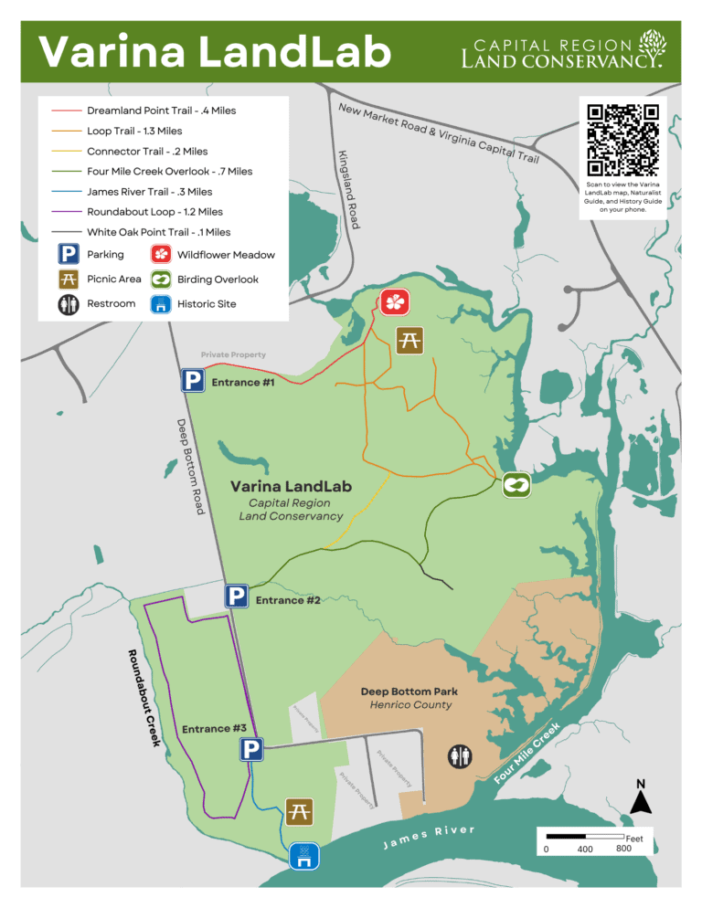
Trailhead #1 – 8951 Deep Bottom Road, Richmond, VA 23231
Trailhead #2 – 9051 Deep Bottom Road, Richmond, VA 23231
Trailhead #3 – 9200 Deep Bottom Rd, Richmond, VA 23231 (Get Directions)
This 353-acre Varina LandLab property on Deep Bottom Road was gifted to CRLC in 2021 to support public access to the outdoors and environmental education opportunities. The property has been permanently protected since 2017 by a conservation easement co-held by CRLC and the Henricopolis Soil and Water Conservation District. Dedicated for public access, trails will open for hiking and birding in May 2023.
The Varina LandLab is located in eastern Henrico County adjacent to Deep Bottom Park and fronts the James River, Four Mile Creek, and Roundabout Creek. It is dubbed a “LandLab” for its purpose as an outdoor classroom for local K-12 students, University classes, and curious minds of all ages. The biodiversity that can be found at Varina LandLab is extraordinary and offers an opportunity to learn about ecology, sustainability, and effective land management. As an example, Virginia Commonwealth University biology students utilize the property for field investigation of migratory birds within the Lower James River Important Bird Area and citizen scientists are encouraged to record their observations through apps such as eBird and iNaturalist.
Since taking ownership of the property in 2021, CRLC and its many partners have planted over 1000 trees to expand the riparian buffer, restored 500 feet of an eroding drainage area, conducted prescribed burns on 40 acres of grassland, experimented with alternative treatments of invasive species, and preserved sensitive natural communities of native plants.
This landscape also bears witness to layers of indigenous, colonial, and Civil War history. From the high ground along Four Mile Creek where indigenous people lived since 2,000 BCE until the establishment of the English settlement at Henricus to bluffs overlooking the James River at an important pontoon bridge crossing that more than 28,000 Union troops used during the Civil War and battles of First Deep Bottom, Second Deep Bottom, and New Market Heights, this hallowed ground can reveal many untold stories3
Park Rules
Rules and Restrictions:
- Park Open from Sunrise to Sunset. No trespassing after dark.
- Leave No Trace. Take only pictures. Carry out all trash.
- Keep Pets on Leash. Clean up after your pet and take waste with you.
- Use Open Trails Only. Please stay on designated trails and obey closures.
- Be Safe / Be Sensible. Bring water. Wear sunscreen. Check for ticks.
- Need to use the Restroom? Closest bathroom is at Deep Bottom Park.
- Watch your Step. Unlevel trails can be a hazard.
*Prohibited Activities:
- Unleashed Dogs
- Fires, Smoking, or fireworks
- Camping or Overnight Parking
- ATVs & Other Off-Road Vehicles
- Mountain Biking & Horseback Riding
- Hunting, Trapping, and Fishing
- Alcoholic Beverages
- Feeding Wildlife
- Removal or Destruction of: Plants, Animals, Minerals, & Artifacts
*unless otherwise permitted by CRLC
Offenders who break conservation area rules will be prosecuted.
Notice: Photo and video recording devices in use at Varina LandLab for wildlife and security monitoring.
Varina LandLab Gallery
More Information
Contact
Ashley Moulton
CRLC Land Stewardship Manager
(703) 554-5860 | ashley@capitalregionland.org
Read More

2024 Marks Major Strides at Varina LandLab Conservation Area
National Public Lands Day Features Site-Specific Art Installation
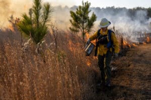
A Fire-Loving Landscape: Prescribed Burns at Varina LandLab
